Vermilion Cliffs National Monument is a destination that feels otherworldly, offering surreal geology, solitude, and limited access that keeps it unspoiled.
Adventurers who prefer fewer crowds and dramatic desert scenery find this place ideal. Hikers, photographers, and off-the-grid travelers come here for experiences that are as rewarding as they are challenging.
Remote terrain and controlled entry make every visit feel special and unforgettable.
Overview of the Monument
- Vast sandstone formations shaped by erosion
- Towering cliffs and isolated plateaus
- Slot canyons that require careful navigation
- Rare wildlife such as California condors
- A sense of solitude unmatched in more crowded destinations
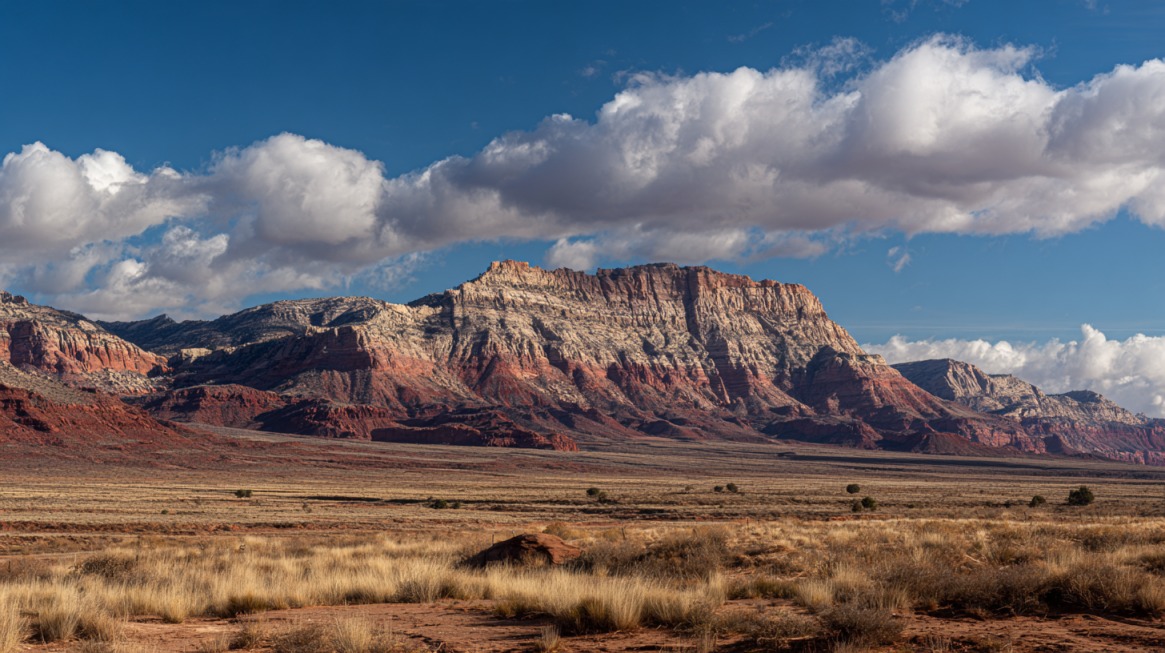
Vermilion Cliffs National Monument is more than just a desert preserve; it is a vast expanse of raw geological beauty and rare solitude.
Its location along the Arizona–Utah border makes it both remote and captivating, with terrain that challenges even seasoned adventurers.
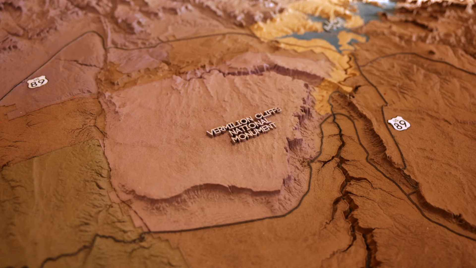
The monument covers an estimated 280,000 to 300,000 acres, managed by the Bureau of Land Management to ensure its fragile ecosystem remains intact.
High desert plains blend seamlessly with massive sandstone cliffs, plateaus, and narrow slot canyons carved over millions of years. Wildlife adds another layer of vibrancy, as California condors glide overhead and hardy desert plants cling to life in seemingly inhospitable soil.
Visitors often describe the sheer sense of scale as overwhelming, with horizons that stretch endlessly and trails that demand resilience. Remote conditions make it a destination for those seeking both challenge and reward.
Top Attractions to See
Each attraction within Vermilion Cliffs offers its own character, ranging from world-famous formations to hidden corners known only to seasoned travelers. Below are some of the most remarkable highlights.
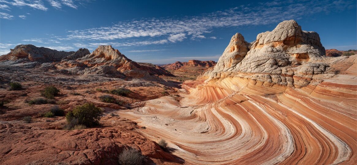
The Wave (Coyote Buttes North)
Considered the crown jewel of Vermilion Cliffs, The Wave features swirling ribbons of red, orange, and yellow sandstone that seem almost painted by hand.
Entry is tightly controlled through a highly competitive permit system, adding rarity to the experience.
Hiking to The Wave requires a three-mile trek across exposed desert with no shade, demanding careful planning.
- Second Wave with layered rock resembling frozen waves
- Top Rock Arch, a natural arch perched high above
- Melody Arch, offering delicate sculpted curves
Many visitors spend hours here, photographing intricate patterns and savoring the silence of the desert.
White Pocket
View this post on Instagram
White Pocket serves as a breathtaking alternative to The Wave, with equally dazzling formations but without the strict permit requirements.
Reaching the site requires a high-clearance 4WD vehicle, as sandy roads are treacherous for standard cars.
- Swirling sandstone in vivid reds, whites, and yellows
- Fewer visitors, creating a peaceful experience
- Optimal conditions for sunrise and sunset photography
Travelers often describe the site as a painter’s palette shaped by wind and time, rewarding those willing to tackle the difficult access.
South Coyote Buttes (Paw Hole & Cottonwood Cove)
View this post on Instagram
South Coyote Buttes requires permits, though they are far easier to obtain than for Coyote Buttes North. The area is known for its dramatic rock formations shaped like teepees, hoodoos, and sculpted spires.
Cottonwood Cove, in particular, dazzles with striking color bands, while Paw Hole offers surreal formations that ignite the imagination.
- Teepee-shaped rock clusters in glowing colors
- Hoodoos balanced across eroded plateaus
- Remote camping just outside wilderness zones
Those who visit enjoy both accessibility and solitude, making it an excellent choice for photographers and backcountry hikers.
Paria Canyon & Buckskin Gulch
Paria Canyon offers a multi-day trek filled with history, geology, and natural beauty.
Hiking through the canyon reveals towering red walls, riparian oases shaded by cottonwood trees, and ancient petroglyphs carved into the rock. An overnight permit is required, ensuring the experience remains unspoiled.
Buckskin Gulch complements Paria as one of the longest slot canyons in the world.
Narrow passages and towering walls create both drama and risk, especially with the ever-present danger of flash floods. Careful planning is essential for those venturing into its corridors.
- Multi-day trekking through Paria’s winding corridors
- Ancient petroglyphs etched into canyon walls
- Buckskin Gulch’s towering, narrow passageways
- Flash flood risk that requires caution and preparation
For many, these canyons represent the most rewarding backcountry experiences in the monument.
Edmaier’s Secret & Double Barrel Arch
View this post on Instagram
Adventurers seeking less-visited sites gravitate toward Edmaier’s Secret.
Strange formations rise across the desert, some resembling mythical creatures such as “resting dragon.” Double Barrel Arch, shaped by erosion into a twin-arched spectacle, adds to the area’s intrigue.
- Rock formations resembling creatures or sculptures
- Natural twin arch known as Double Barrel Arch
- Lack of permits, offering freedom for those who find their way
Access is difficult, demanding navigation skills and determination. For those who make the effort, solitude and discovery reward every step.
Marble Canyon & Cathedral Wash
@thewildiswaiting Hiking up Cathedral Wash in the Marble Canyon area of Arizona. This is a fun hike that runs from the road down to the Colorado River. There are a few scrambles on the hike where you need to use your upper body to navigate. Total photos in this clip: 641 Total time to shoot: 42 minutes #arizona #hiking #outdooradventures ♬ original sound – Mulligan Brothers
Marble Canyon is among the more accessible areas, lying close to Highway 89A and Cliff Dwellers Lodge. Towering cliffs overlook the Colorado River, creating views that capture both strength and beauty.
Cathedral Wash provides a moderate hiking experience, leading through dry streambeds toward the river while offering panoramic canyon vistas.
- Accessibility compared to other attractions
- Striking cliffside views of the Colorado River
- Moderate trails suitable for shorter day trips
Marble Canyon and Cathedral Wash serve as excellent options for those with limited time who still want memorable experiences.
Planning Your Trip
A trip to Vermilion Cliffs requires thorough preparation. Harsh conditions, strict permit rules, and remote access mean only those who plan carefully will fully enjoy the experience.
Permits & Regulations
Different areas within the monument follow specific rules. Coyote Buttes North requires entry through a lottery, making permits highly competitive. Coyote Buttes South also requires permits, though they are easier to secure.
Overnight treks into Paria Canyon need additional permits, while White Pocket remains unrestricted at present.
- Verify regulations on the Bureau of Land Management website
- Apply for necessary permits in advance
- Practice Leave No Trace principles to protect fragile environments
Getting There
Accessing Vermilion Cliffs is not simple. House Rock Valley Road serves as the primary route, but conditions vary dramatically with weather.
Sandy stretches and unmarked roads make navigation difficult without proper vehicles and preparation.
- High-clearance 4WD vehicle for sandy or muddy conditions
- Reliable GPS and physical maps due to poor signal coverage
- Awareness of weather conditions to avoid impassable roads
When to Go
Seasonal timing plays a crucial role in planning. Spring and fall provide the most favorable conditions, with moderate temperatures and stable trails.
Summer presents extreme heat and exposure risks, while winter may bring ice and snow that block access.
- April through June for spring wildflowers and mild weather
- September through November for cool temperatures and vivid skies
- Winter months only for those prepared for snow and icy routes
Where to Stay
Accommodation options vary according to preference. Cliff Dwellers Lodge offers a convenient base near the monument, while towns such as Kanab, Utah, and Page, Arizona, provide hotels, restaurants, and supplies.
For those who prefer immersion in the desert, primitive camping is permitted in designated areas outside wilderness boundaries.
- Cliff Dwellers Lodge with food and lodging
- Kanab and Page for expanded amenities
- Primitive campsites for those seeking desert solitude
View this post on Instagram
Suggested Itineraries
Visitors often ask how much time to allocate, and the monument offers flexibility depending on the length of stay.
1-Day Visit
A single day allows enough time for White Pocket or a shorter trek into Paria Canyon. Many end the day with sunset photography across the cliffs, capturing dramatic color shifts.
2-Day Visit
Two days create opportunities for pairing White Pocket with South Coyote Buttes. Those lucky enough to secure a permit might devote one day entirely to The Wave.
3–5 Day Adventure
Extended trips enable multi-day backpacking adventures through Paria Canyon, starting at White House Trailhead and ending at Lees Ferry. Additional days allow for side trips into Buckskin Gulch, Paw Hole, and Cottonwood Cove, giving travelers more opportunities to capture the raw essence of Vermilion Cliffs.
Final Thoughts
Vermilion Cliffs National Monument remains one of the most mystical and remote destinations in the American Southwest.
Adventurers drawn here find either world-famous formations such as The Wave or silent stretches of sandstone that feel untouched.
Careful preparation ensures safety while unlocking unforgettable beauty. For those who invest the time and effort, few places compare in terms of solitude, scenery, and photographic opportunities.