Few mountains capture the American imagination quite like Pikes Peak. Rising above Colorado Springs in the southern Rockies, it’s not just a mountain but a symbol of exploration, endurance, and the sheer love of wide-open views.
We prepared everything you should know: numbers, stories, and the practical stuff that keeps your trip smooth from gate to summit. Let’s get started.
Quick Facts at a Glance
| Detail | Information |
| Summit Elevation | 14,115 feet (4,302 meters) above sea level |
| Highway Distance | 19 miles from the toll gate to the summit |
| Location | West of Colorado Springs, inside Pike National Forest |
| Managing Authority | City of Colorado Springs |
| Summit Visitor Center | Opened in 2021, includes exhibits, café, and altitude-baked doughnuts |
| Other Routes Up | Broadmoor Manitou & Pikes Peak Cog Railway, Barr Trail hike |
Elevation and Geography
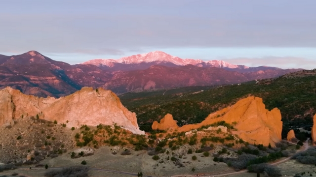
At 14,115 feet, Pikes Peak is one of Colorado’s most famous “fourteeners.” It rises dramatically from the plains, creating a natural landmark visible for miles. The mountain anchors Pike National Forest and dominates the Front Range skyline.
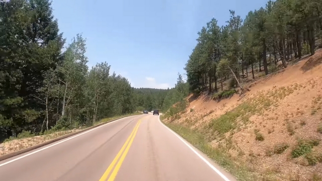
Driving up the 19-mile Pikes Peak Highway is like passing through several worlds in a single trip. You start in forests of ponderosa pine and end in alpine tundra, where oxygen thins and temperatures drop sharply. The transition is quick enough to feel like time travel.
The summit sits over a mile above downtown Colorado Springs, which already lies around 6,000 feet. That climb in elevation explains the sudden chill and thinner air near the top.
Why 14,115 Feet Matters
Colorado has more than 50 peaks over 14,000 feet, but Pikes Peak stands out because it’s both lofty and easy to reach. You don’t need technical climbing skills or a week of backpacking.
You can drive, ride the cog railway, or hike. That mix of altitude and accessibility makes it one of the most visited summits in North America.
Many locals consider it the most approachable of the state’s fourteeners, while still giving a full high-mountain experience. On a clear day, the view stretches across the Great Plains, over the San Juan Mountains, and even toward New Mexico.
History
Pikes Peak’s story stretches far beyond scenic drives and summit selfies. It’s past weaves together Indigenous traditions, early expeditions, and moments that helped shape American culture.
Indigenous Presence
Long before European explorers arrived, Native tribes of the region revered the mountain. Early accounts mention Indigenous names tied to the sun or sky, showing how spiritual and geographic significance blended in oral traditions.
1806: Zebulon Pike Spots the “Grand Peak”
In November 1806, Army officer Zebulon Pike led an expedition through what was then part of the newly acquired Louisiana Territory.
He spotted the massive summit from far across the plains, tried to climb it, and turned back in heavy snow. Though he never reached the top, his name stuck.
1820: First Recorded Ascent
Botanist Edwin James successfully reached the summit in July 1820 during Major Stephen Long’s expedition. His notes became the first confirmed record of anyone standing atop a 14,000-foot peak in the modern United States.
1859: “Pike’s Peak or Bust”
During the Colorado Gold Rush, prospectors painted those words on wagons heading west. Most mining took place elsewhere, but Pikes Peak became the symbol of opportunity. The slogan stuck in American culture as shorthand for the Western dream.
1893: Inspiration for “America the Beautiful”
“America the Beautiful” is a patriotic American song. Its lyrics were written by Katharine Lee Bates and its music was composed by church organist and choirmaster Samuel A. Ward at Grace Episcopal Church in Newark, New Jersey in 1882.
— Joe Schad (@schadjoe) February 11, 2024
Katharine Lee Bates, a Wellesley College professor, rode to the summit during a summer in Colorado Springs.
The sweeping view inspired her to write a poem that became the patriotic song America the Beautiful. Her own writings describe the awe she felt looking over the endless plains.
1891 to Today: The Cog Railway
Entrepreneur Zalmon Simmons financed a cog railway that opened in 1891, carrying passengers from Manitou Springs to the top. After major upgrades, it reopened in 2021 as the Broadmoor Manitou & Pikes Peak Cog Railway – the highest cog line in the country.
1915: The Highway Opens
Businessman Spencer Penrose funded the Pikes Peak Highway, turning the summit into a drive-up attraction. Today, the road is fully paved and managed by the City of Colorado Springs. Timed-entry reservations are required in peak summer months.
1916 to Present: The Hill Climb
The Pikes Peak International Hill Climb began in 1916 and remains one of the most challenging races in the world. Drivers tackle 12.42 miles, 156 turns, and a finish line at 14,115 feet. It’s America’s second-oldest motorsport event, held every June.
Three Ways to the Top
There’s more than one way to reach Pikes Peak’s summit:
1. Drive the Pikes Peak Highway
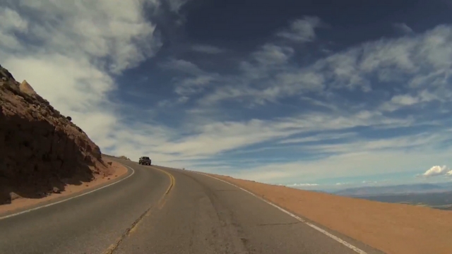
- Distance: 19 miles from gate to summit
- Typical Time: 1.5 to 2 hours each way, depending on stops
- Reservations: Required for personal vehicles in summer (book through the official site)
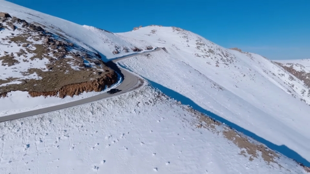
The drive is spectacular. You’ll pass forests, lakes, and tundra before rolling into the clouds. But it’s also serious mountain driving, so follow official safety advice carefully.
Driving Tips from Local Rangers
- Use low gear both uphill and downhill.
- Avoid constant braking to prevent overheating.
- Never pass on blind curves.
- Expect brake-temperature checks at Glen Cove. If your brakes are hot, you’ll need to cool them before continuing.
Weather Tip
Conditions can change fast. The summit can be 30 to 40°F colder than Colorado Springs, and wind gusts often exceed 40 mph. Always pack layers, gloves, sunscreen, and water.
2. Ride the Broadmoor Manitou & Pikes Peak Cog Railway
If you’d rather relax and watch the scenery, the cog railway is ideal. It runs from Manitou Springs directly to the summit and is the highest cog line in the United States.
After a total rebuild, it reopened in 2021 with modern trains and a smoother ride. The trip takes about three hours round-trip, including time at the top to explore the Summit Visitor Center.
Book well ahead in summer – the railway sells out quickly.
3. Hike the Barr Trail
View this post on Instagram
For those who prefer to earn every step, the Barr Trail is a serious workout:
- Distance: 13 miles one way
- Elevation Gain: Over 7,000 feet
- Difficulty: Rated “difficult” by the U.S. Forest Service
Many hikers camp overnight at Barr Camp to split the climb. Starting before dawn is essential to avoid lightning, which is common above treeline in the afternoon. Some hikers ride the cog railway down to spare their knees.
For those who enjoy multi-day trips, reading about the 10 best campsites in Canyonlands National Park can offer fresh ideas for planning future outdoor adventures.
The trail rewards you with changing ecosystems, from pine forest to tundra, and views that unfold gradually rather than all at once.
Health and Altitude Tips That Actually Help
Even seasoned hikers feel the altitude on Pikes Peak. The air at 14,000 feet has about 40% less oxygen than at sea level, which means simple activities can feel like workouts.
Practical Tips
- Hydrate well. Dehydration hits fast at high elevation.
- Acclimate. Spend a day around 6,000–7,000 feet before going higher.
- Skip alcohol on the first day. It worsens dehydration and altitude effects.
- Dress in layers. Expect a temperature drop of 30–40°F between town and summit.
- Protect your skin and eyes. UV rays intensify with altitude; snow glare can be harsh.
People with heart or lung conditions should consult a doctor before visiting the summit. Infants and those with severe altitude symptoms should stay at lower elevations or take the cog railway instead of driving.
What You’ll Find at the Summit
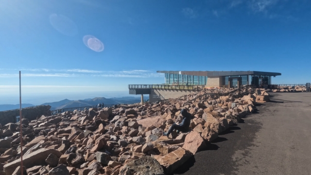
The Summit Visitor Center, completed in 2021, redefined the top of Pikes Peak. It’s a modern, sustainable building designed to handle extreme weather. Inside, you’ll find:
- Educational exhibits about geology and local history
- A café serving the famous altitude doughnuts
- Restrooms and indoor seating
- A 360-degree outdoor boardwalk with panoramic views
The doughnuts deserve their reputation – they only cook correctly at 14,000 feet because the recipe depends on lower air pressure. Eat them fresh; they go flat on the way down.
Outside, the summit paths guide you to viewpoints that stretch across the plains, the Continental Divide, and far into the San Luis Valley.
The Hill Climb That Made Racers Famous
Each June, racers from around the globe tackle the Pikes Peak International Hill Climb, often called “The Race to the Clouds.”
The course begins at 9,390 feet and ends at 14,115. Cars, motorcycles, and electric prototypes compete to set records in one of the world’s most dramatic motorsport events.
If you visit in late June, check the official race schedule. The highway closes for competitors and crews, and the mountain becomes a temporary racetrack.
Tickets, Hours, and Seasonality
- Highway Operations: Open year-round when weather allows. In winter, the road may open only to a lower elevation.
- Summer Hours: Uphill gates usually open at 7:30 a.m.
- Reservations: Required for summit drives from late May through September.
- Admission Rates: Updated annually by the City of Colorado Springs and posted online.
- Cog Railway: Runs on a fixed schedule; book early during peak months.
Always call the road conditions line before heading out. Storms, snow, or high winds can close upper sections even on sunny mornings.
Driving Tips That Make the Day Smoother
Driving up Pikes Peak is stunning but demanding, so a few smart habits can make all the difference. Here’s how to keep your climb safe, steady, and stress-free.
Before You Go
- Check the official website or call the recorded hotline for current hours.
- Fill your gas tank – there’s no fuel on the mountain.
- Bring water, snacks, and extra clothing layers.
- Double-check your reservation window if visiting in summer.
On the Way Up
- Drive in low gear to reduce strain on your engine.
- Watch for wildlife; marmots and deer are common.
- Pull into scenic turnouts to let faster cars pass.
At the Summit
- Let your engine idle briefly before shutting off.
- Take it slow when walking; the altitude can sneak up on you.
- Warm up, hydrate, and enjoy the views before heading down.
On the Way Down
- Use low gear for engine braking.
- Avoid holding the brake pedal constantly.
- Stop at Glen Cove for the brake-temperature check. Rangers will let you cool down if necessary – nothing to worry about.
FAQs
Final Words
@divyadiscovers who’s adding this drive to their colorado bucket list?! 👀 welcome to PIKES PEAK – colorado’s legendary 14,115 ft summit, better known as america’s mountain driving up pike’s peak is unlike any road you’ve ever been on. 19 miles to the summit, 156 turns, and views that make every switchback worth it. halfway up you’ll hit a mandatory brake check (yes, it’s THAT steep) and by the time you reach 14,115 ft, it feels like you’re driving straight into the sky #pikespeak #coloradobucketlist #coloradoroadtrip #thingstodoincolorado #coloradotravel ♬ original sound – Divya
Pikes Peak isn’t just a tall mountain – it’s a living piece of American heritage. Its mix of accessibility, history, and raw beauty has inspired explorers, poets, and racecar drivers for over two centuries.
Whether you reach the summit on four wheels, two rails, or two feet, the experience stays with you.
Just remember: plan ahead, respect the weather, and take your time up high. The view from 14,115 feet speaks for itself.