Southern Utah is packed with iconic stops that make it onto every road trip list: Bryce Canyon, Capitol Reef, and the endless slickrock stretches of Grand Staircase.
But sitting quietly above the town of Escalante, tucked on a mesa above a desert reservoir, is a park that carries a story even older than dinosaurs.
Escalante Petrified Forest State Park is not loud, not crowded, and not widely marketed. Yet, for those who pause and walk its short trails, it offers one of the richest concentrations of petrified wood in the entire West.
We prepared a practical, detailed guide to the park: how it came to be, what you’ll see on the ground, and why it’s worth carving out a half-day stop on your Highway 12 itinerary.
Key Facts
| Topic | Detail |
| Location | Mesa above Wide Hollow Reservoir near Escalante, Utah |
| Trails | Petrified Forest Trail (1.0 mi), Sleeping Rainbows Loop (0.75 mi add-on) |
| Reservoir | 130 acres, paddling, swimming, fishing |
| Best Seasons | Spring and fall for hiking; summer for water activities |
| Rules | No collecting petrified wood or fossils inside the park |
| Climate | 10-11 inches of annual precipitation, hot summers, cold winters |
| Accessibility | Road and picnic areas are accessible, but trails are not fully barrier-free |
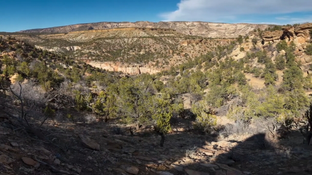
Where You’re Standing in the Big Picture
The park sits just outside the small town of Escalante, along Utah’s Scenic Byway 12.
From the parking lot, you can see Wide Hollow Reservoir, a compact desert lake, and just above it, a mesa scattered with logs turned to stone.
The official overview highlights three pillars of the park experience:
- Swimming, paddling, and fishing at Wide Hollow Reservoir
- Two hiking loops across the mesa, both full of petrified wood
- A small but informative visitor center with exhibits
At only a few hundred acres, the park is modest in scale, yet the ground beneath your feet carries a story more than 150 million years old.
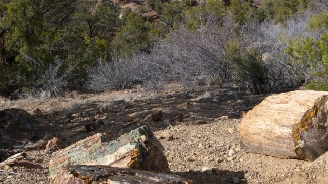
Why Escalante’s Petrified Wood Is Special
View this post on Instagram
The fossil logs you see on the mesa are Late Jurassic in age, part of the famous Morrison Formation that stretches across much of the American West.
The same rocks that yield dinosaur bones at places like Dinosaur National Monument also preserved entire forests. Here in Escalante, trees once buried in river floodplains were saturated with silica-rich groundwater.
Cell walls were replaced by microcrystalline quartz, locking in color and texture. Over millions of years, erosion has cut into the mesa, exposing logs in bright hues of red, yellow, purple, and black.
The Science in Plain English
Petrified wood forms when trees are rapidly buried in sediments, often by floods or volcanic ash. As mineral-rich water circulates through the buried logs, spaces in the wood fill with silica.
Over time, the organic material decays, but the mineral molds stay, creating a quartz replica of the original tree. In Escalante, the logs are concentrated in the Brushy Basin Member of the Morrison Formation.
This layer is full of volcanic ash and clay, a perfect environment for silica to saturate wood. Coarse gravels cap the mesa, protecting it from erosion, while gullies and slopes reveal logs in spectacular density.
Trails That Show It All
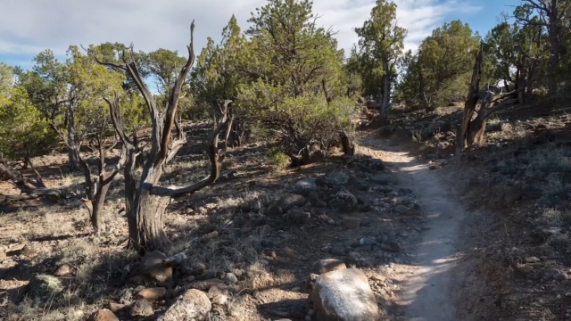
The best way to see the petrified wood is by hiking the park’s two linked loops. Both start from the main parking lot above Wide Hollow Reservoir.
Petrified Forest Trail
- Length: 1.0 mile loop
- Time: 45-75 minutes
- Surface: Packed dirt, moderate climb
- Why go: Views across the reservoir, scattered fossil logs, family-friendly
This is the gentler trail. It climbs gradually to the mesa top, where you can spot petrified logs in small clusters while enjoying open views of desert country.
Sleeping Rainbows Trail
- Length: 0.75 mile loop (add-on)
- Time: 40-60 minutes
- Surface: Steeper, rocky, short scrambles
- Why go: Dense concentrations of colorful fossil wood
The Sleeping Rainbows Trail is where things get dramatic. Logs are everywhere, often larger and more colorful than those on the main loop.
Trail Comparison at a Glance
| Trail | Distance | Time | Surface & Grade | Why Go |
| Petrified Forest Trail | 1.0 mi | 45-75 min | Moderate, packed dirt | Good intro, views, scattered logs |
| Sleeping Rainbows Loop | 0.75 mi | 40-60 min | Steep, rocky, scrambles | Heavy concentrations of large logs |
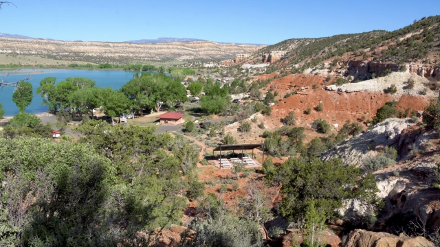
The Reservoir Next Door
@cristian_avaloss Sand Hollow State Park. Beautiful place! #sandhollow #sandhollowstatepark #lake #sunsets #summervibes #fyp #foryoupage #follow #like ♬ Summer – Calvin Harris
Wide Hollow Reservoir, at roughly 130 acres, doubles the park’s appeal. In summer, visitors paddle kayaks or relax on paddleboards. Kids swim from the shore, and anglers try their luck from the bank.
According to Utah’s Division of Wildlife Resources, the reservoir is stocked with rainbow trout, and often supports bluegill and largemouth bass.
Year-to-year stocking varies, but the setting stays family-friendly. Camping spots line the lakeshore, and rentals for paddleboards and kayaks are often available during the warmer months.
Rules That Matter
Escalante Petrified Forest State Park has one rule you’ll see repeated on signs, brochures, and the website: do not collect petrified wood. Photograph as much as you like, but leave every piece where it sits.
Utah’s broader rules can cause confusion. On some Bureau of Land Management (BLM) lands outside the park, personal collection of petrified wood is legal in small amounts, with daily and yearly limits.
None of those allowances applies inside state parks. A well-known local legend is the “petrified wood curse,” where visitors who take a chunk supposedly suffer bad luck and later mail it back. Regardless of belief, the lesson is simple: leave the logs in place.
Practical Details
Fees and Hours
- The park charges a day-use fee. Always check Utah State Parks’ live fee schedule for updates.
- Seasonal hours vary. Summer offers long days, while spring and fall may see shorter schedules.
Facilities
- Lakeside campgrounds with RV hookups and tent sites
- Shaded picnic tables
- A visitor center with fossil displays and regional geology exhibits
Accessibility
The main road, picnic areas, and reservoir are car-accessible. The trails themselves involve climbs and are not fully barrier-free. For those who don’t hike, the visitor center and lakeshore provide plenty to see.
Climate and Best Times to Visit
Escalante sits at roughly 5,800-5,900 feet. Climate data from NOAA shows the area receives just 10-11 inches of precipitation per year, with a dry spring and brief monsoon storms in late summer.
- Summer: Highs in the 80s to 90s Fahrenheit, often hot by midday. Afternoon monsoon storms are common in July and August.
- Winter: Cold, with highs around freezing in January.
- Spring & Fall: The sweet spots. Warm days, cool nights, less crowding.
A Quick Field Guide to the Rocks
- Formation: Morrison Formation, Brushy Basin Member
- Age: Around 150 million years old (Late Jurassic)
- Environment: Floodplains and rivers depositing clay, sand, and volcanic ash
- Why it matters: The Same rocks that host dinosaur fossils across Utah also preserved entire forests here
Escalante’s petrified logs are classic examples of Morrison Formation fossil wood, used frequently in geology courses and surveys as textbook samples.
Safety Notes for Visitors
- Heat and Elevation: Carry more water than you think you need. Use sunscreen, wear a hat, and pack a light snack.
- Footing: The Sleeping Rainbows loop includes sandy, steep descents. Closed-toe hiking shoes are highly recommended.
- Leave No Trace: Don’t stack or move logs for photos. It damages the site and violates park rules.
Birding and Wildlife
The reservoir attracts seasonal waterfowl, including ducks, geese, and the occasional heron. Raptors circle above the mesa, taking advantage of desert thermals.
Pinyon and juniper woodlands support small songbirds and lizards that dart across the trail. For anglers, the Utah DWR’s stocking reports are worth checking.
Rainbow trout are common, with warmwater species appearing in summer.
A Sample Half-Day Itinerary
Hour 1: Stop at the visitor center to grab a trail guide. Walk the Petrified Forest Trail clockwise, pausing at logs and viewpoints.
Hour 2: Branch onto the Sleeping Rainbows loop for the densest concentrations of petrified wood. Take time to photograph, then rejoin the main trail.
Hour 3: Picnic at lakeside tables, followed by a paddle, swim, or quick fishing session if the weather is warm.
Responsible Collecting Explained Clearly
- Inside the park: Collecting petrified wood is illegal.
- Outside, on BLM lands: Personal collection may be allowed up to 25 pounds plus one piece per day, with a 250-pound annual maximum. Commercial collecting requires contracts.
- Fossils (dinosaurs, vertebrates, etc.): Illegal to collect on state or federal lands without a permit.
Always confirm with local offices before collecting outside protected areas.
Pairing the Park With Nearby Stops
View this post on Instagram
Escalante Petrified Forest makes an easy addition to a broader loop through southern Utah. Within short drives, you can reach:
- Calf Creek Recreation Area: Lower Calf Creek Falls hike, one of Utah’s most photographed waterfalls.
- Scenic Byway 12 Pullouts: For sweeping views of slickrock country.
- Bryce Canyon National Park: About 45 miles west, ideal for sunrise or sunset over hoodoos.
Final Thoughts
Escalante Petrified Forest State Park is small, easy to overlook, and often quiet compared to Utah’s marquee sites. Yet the experience of walking among stone logs that once shaded a Jurassic floodplain is profound.
The colors are vivid, the science is tangible, and the setting is peaceful. If your road trip runs along Scenic Byway 12, carve out a few hours. Start early, walk both loops if you can, and then sit for a moment among the fossil logs.
In a landscape full of big names, Escalante offers a quieter prehistoric story, one that rewards those who take the time to stop and look closely.