Montana offers some of the most striking and powerful landscapes in North America. With its wide-open skies, rugged mountains, deep forests, and quiet towns, it creates a sense of space and freedom that’s hard to match. Every region holds something unique—geological wonders, rich history, untouched wilderness, and vibrant local culture.
This list focuses on places that capture the essence of Montana.
1. Many Glacier
Located on the east side of Glacier National Park, Many Glacier is one of the most dramatic alpine landscapes in Montana. It’s an area defined by glacial lakes, vertical cliffs, and trails that immediately launch into high-elevation terrain.
Unlike other entrances to the park, this one places you directly inside the grandeur, with no long drive required to reach stunning views.
Hiking access and terrain
The Grinnell Glacier Trail and Iceberg Lake Trail both begin from the valley and climb steadily into terrain shaped by ancient ice. These are not simple strolls — elevation gain is steady, and snow lingers well into early summer.
Hikers pass through alpine meadows, waterfalls, and talus slopes with regular chances to spot moose, bighorn sheep, and grizzly bears.
Logistics and seasonal planning
The road into Many Glacier is paved but frequently under construction and subject to closures or delays. Summer crowds fill the parking lot by sunrise.
Lodging at Many Glacier Hotel and Swiftcurrent Motor Inn sells out nearly a year in advance, while campgrounds run on a reservation lottery. Bear safety isn’t optional — this region has one of the densest grizzly populations in the lower 48.
2. Makoshika State Park
View this post on Instagram
In the far eastern edge of the state, Makoshika stands apart from Montana’s mountain image. This is badlands country — wind-sculpted rock, fossil beds, and sharp, dry ridgelines stretching under an endless sky.
The name comes from a Lakota phrase meaning “bad land,” and that ancient presence is still felt in its silence and space.
Fossils, formations, and dryland ecology
Makoshika contains active dinosaur fossil sites, including partial triceratops skeletons. Trails like the Diane Gabriel Trail pass by exposed fossil beds and eroded hoodoos.
This is high desert, home to golden eagles, prairie lizards, and sharp-tailed grouse. The land holds heat, bakes in summer, and reveals a raw version of Montana not found anywhere else in the state.
Trail conditions and visitor strategy
Trails are narrow, exposed, and mostly unshaded. Bring more water than you think you’ll need, wear sun protection, and hike early.
Most visitors don’t stray far from the scenic drive — those who hike in deeper find complete solitude. Glendive is the nearest town, with basic lodging and supplies, but little else. This is a park for those who are prepared and self-reliant.
3. Polebridge and the North Fork
North of Glacier’s west entrance, the road turns to gravel, cell service disappears, and the last traces of infrastructure vanish into forest.
Polebridge isn’t a town in the normal sense — it’s a collection of cabins, one famous bakery, and access to one of the most remote corners of the national park.
Living off-grid
The Polebridge Mercantile, powered by solar and generator, serves fresh-baked pastries, bread, and local goods daily — with a reputation that’s spread far beyond the valley.
Residents here live without grid electricity or modern amenities, especially in winter. Summer brings a rotating mix of travelers, locals, and park workers looking for coffee and conversation in the middle of nowhere.
Accessing the wilderness
Beyond Polebridge, dirt roads lead to Bowman and Kintla Lakes — deep, glacier-fed waters with few facilities and fewer people. These lakes offer some of the quietest overnight camping in Glacier.
There are no rangers nearby, and rescue isn’t fast. Vehicles need clearance and full tanks. Trails begin at lake edge and climb into wild, unregulated terrain.
4. Beartooth Highway
The Beartooth Highway runs from Red Lodge to the northeast entrance of Yellowstone National Park, crossing one of the highest-elevation paved roads in the continental United States.
It climbs above the tree line into a world of alpine plateaus, frozen lakes, and bare granite ridges. The views shift every mile — forests give way to snowfields, and valleys fall away beneath you with little warning.
What makes it memorable
- Elevation tops out at 10,947 feet, with panoramic viewpoints like Beartooth Pass Overlook offering unobstructed views across two states.
- Bear’s Tooth Peak, for which the highway is named, juts sharply above the plateau and can be seen from multiple points along the road.
- Wildflowers bloom late — often in July — turning the tundra into a dense, colorful carpet.
Driving conditions and timing
The highway is only open seasonally, typically from late May through mid-October, depending on snowfall. Sudden storms are common even in summer, and nighttime temperatures can drop below freezing.
RVs and trailers are discouraged on the switchbacks between Red Lodge and the plateau due to steep drop-offs and narrow lanes.
5. The Yaak Valley
Most Montanans have never been to the Yaak — and many couldn’t point to it on a map. Tucked in the state’s far northwestern corner, near the Idaho border, the Yaak is a forested maze of rivers, creeks, ridges, and old logging roads.
It’s one of the most biologically diverse areas in the northern Rockies, home to rare species like the fisher, the wolverine, and the threatened grizzly.
The people who live here don’t do it casually. The community is small, seasonal, and fiercely independent. There are no chain stores, few marked trailheads, and most roads are gravel. But for those who seek silence and density — of forest, of wildlife, of time — the Yaak delivers something close to spiritual.+
Local recommendations from people who live here
- Hike to Caribou Peak: There’s no trailhead sign. Locals will tell you how to get there, or you’ll find it on your third try.
- The Dirty Shame Saloon: Half tavern, half town center. Expect stories from trappers, artists, and travelers who lost the highway and didn’t mind.
- Cabin stays: Skip hotels — there aren’t any. Look for off-grid rentals along Yaak River Road. Most are unplugged, and that’s the point.
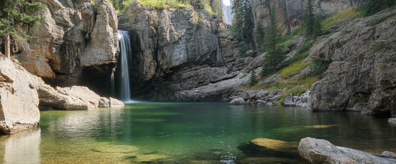
6. Kootenai Falls and Swinging Bridge
The Kootenai River cuts a fast, cold line through northwest Montana, creating one of the most scenic and accessible waterfalls in the state.
Just off U.S. Highway 2 between Libby and Troy, Kootenai Falls drops in a wide, thunderous sheet. A short walk leads from the parking lot to a wooden footbridge that swings gently over the canyon — a view that’s hard to forget.
What makes this a standout stop
The walk to the falls is easy, about 10 minutes from the roadside trailhead, but the payoff is enormous. During peak runoff (usually May to early June), the river is loud enough to drown out conversation. The Swinging Bridge, rebuilt after a wildfire in 2017, gives you an elevated view right over the gorge — not for anyone with a fear of heights.
Film fans may recognize the area from The River Wild — several scenes were shot right at the bridge and riverbend. But it’s not just a backdrop. Locals use the area year-round to fish, swim, or just sit in the spray on hot summer days.
7. The Bob Marshall Wilderness Complex
View this post on Instagram
The Bob, as locals call it, is one of the largest roadless areas in the lower 48. Stretching over 1.5 million acres, it borders Glacier National Park to the south but offers a very different kind of experience — no car access, no visitors’ center, and no shortcuts.
This is the kind of place you enter for a week, not an hour. If Glacier is where you go to witness wilderness, The Bob is where you go to become part of it.
You reach the interior by trail only, and the deeper you go, the more you feel time loosen its grip. There are places in The Bob where it’s not uncommon to walk 20 miles without seeing another person. The wilderness is raw — grizzly tracks, wolf prints, river crossings that shift every spring. But it’s also calm in a way that cities can’t simulate.
Best ways to enter
- Benchmark Trailhead (near Augusta): Gateway to the Chinese Wall, a 1,000-foot-high limestone escarpment that runs for miles across the wilderness.
- South Fork Sun River (near Gibson Reservoir): A longer, scenic approach that follows alpine rivers into high meadows.
- Holland Lake area: Offers more gradual entry and easier loops for those not doing a full pack-in.
8. Paradise Valley
@yourfuzzyscarf My favorite place in the whole world: Paradise Valley, Montana 🫶🍸 #wheretogo #seetheworld #montana #wheretotravel #dreamvacation #mustseeplaces #dreamdestination #dreamdestinations #montanalife #bozeman #beautifulplaces #solotraveler #solotravelwoman #traveltiktok ♬ Smile – Morgan Wallen
Paradise Valley is a perfect name — not poetic, just accurate.
This stretch of land between Livingston and the northern entrance to Yellowstone is bordered by the Absaroka Range to the east and the Gallatin Range to the west, with the Yellowstone River meandering through the middle. The land feels open, quiet, and cinematic.
Let’s frame it as a long-weekend base camp. Here’s how you could spend three grounded, unforgettable days:
3-Days Trip Recommendation
Day 1: Arrival + soaking
Drive south from Livingston. Stop at Chico Hot Springs for a soak in the mineral pools followed by dinner at the main lodge — old-school Montana hospitality meets seasonal menus.
Day 2: Hiking and riverside rest
Morning hike to Pine Creek Falls. Not difficult, but scenic — and the kind of trail where you’ll pass a few locals and dogs. Afternoon: find a stretch of the Yellowstone River and sit. Bring a chair. Bring nothing. That’s the idea.
Day 3: Backroad loop and slow return
Take East River Road south through Emigrant, then loop back on the western side. Stop at the general store. Buy huckleberry jam. Drive with the windows down and stop wherever the view grabs you.
9. Garnet Ghost Town
Field Notes from a Town that Froze in Time
- Elevation: 6,000 ft
- Founded: 1895
- Population (1905): ~1,000
- Population (2025): 0
- Access: 11 miles of dirt road from MT Highway 200
Garnet is not a ghost town in the tourist trap sense. There are no reenactments or animatronics. What’s preserved here are the original log and board structures of saloons, general stores, and family homes — many still intact, silently aging among lodgepole pines.
The town was abandoned around 1905 after the gold dried up. Cold winters and isolation did the rest. Today, the Bureau of Land Management maintains the site with a light touch. Floors creak under your step. Rusted cans line open shelves. Old newspapers sit folded on tables.
When to go
- Late spring and early fall are best — access roads can be muddy and snow-packed well into May.
- Avoid weekends in summer, when visitation picks up and the quiet is lost.
- You can rent an actual cabin on site for overnight stays — a rare chance to sleep in a ghost town legally.
10. Bighorn Canyon National Recreation Area
Straddling the Montana–Wyoming border, Bighorn Canyon offers a scale that surprises even well-traveled Montanans.
Towering sandstone cliffs plunge into a deep turquoise reservoir carved by the Bighorn River, and the entire canyon remains largely under the radar. While Lake Powell or the Grand Canyon draw crowds, Bighorn stays open, spacious, and quiet.+
What visitors usually overlook — and shouldn’t
- Devil’s Canyon Overlook: No hike required. Just park and walk a few feet to one of the most jaw-dropping canyon views in the state.
- Boating the canyon: Launch at Barry’s Landing and explore sheer canyon walls rising 1,000 feet on either side. Rentals available seasonally in Fort Smith.
- Hiking Sullivan’s Knob: A short loop with big rewards — panoramic views of the entire canyon bend and open desert beyond.
11. Red Lodge
View this post on Instagram
Red Lodge isn’t just a launchpad for the Beartooth Highway. It’s a town with roots, resilience, and the right mix of grit and charm.
Old brick buildings line Broadway Avenue, housing bakeries, bars, outdoor outfitters, and a few spots that haven’t changed in decades. The mountains rise just beyond, close enough to make every street feel like a trailhead.
Red Lodge Rhythm — A Local’s Snapshot
7:30 AM – Coffee and pastry at Honey’s
Locals file in post-ski, pre-trail. Gear-laden SUVs parked out front. Mismatched mugs, no corporate vibe.
9:00 AM – West Fork Road drive
Follow the road to the trailhead for Lake Fork or Basin Creek. Not too far, not too tough — just enough to feel the altitude.
1:00 PM – Back in town, bison burger at The Pollard
Historic hotel bar, bartenders who can talk elk migration and ski wax in the same sentence.
Evening – Local brews at Red Lodge Ales
If you’re lucky, someone’s playing music. If you’re luckier, it’s good.
12. Medicine Rocks State Park
This landscape doesn’t scream for attention. It whispers. Soft sandstone pillars rise from prairie grass like weatherworn sculptures.
Each one is carved with natural curves, ancient wind lines, and thousands of inscriptions — initials, symbols, and etchings from centuries of passersby. Some are 100 years old. Some are from last week. Some are sacred.
Format: Scene + Reflection
You arrive late. Sunset slants across the rocks. The formations are taller than expected, maybe 60 feet in places. A golden eagle crosses silently above the grasslands, no wind, just shape and distance. There are no trail signs. You walk between pillars, reading the layers.
Some names are carved deep, methodical — 1910, 1912, 1923. Others are scratched hastily. Mixed in are Native pictographs, now half-eroded. The rocks hold a weight that’s hard to explain. They’re personal and ancient at once.
13. First Peoples Buffalo Jump State Park
Before fences, before highways, this cliff was part of one of the largest buffalo jump sites in North America.
Tribes would use strategic positioning and coordinated effort to funnel herds toward the edge, where the animals would fall — providing food, tools, and materials to last entire seasons.
Why this place matters now
There’s a paved path up to the cliff’s edge. Interpretive signs walk you through the process — how hunters masked themselves as wolves, how the herd was driven in stages, how the jump was only the beginning of the work.
At the top, the view opens wide. The plains stretch forever. It’s a moment of scale — geographic, cultural, human. You don’t have to hike far or climb high to feel the weight of what happened here.
14. Missoula
Missoula is the contradiction Montana wears well — a university town wrapped in rivers and ridgelines, where artists share sidewalks with elk hunters, and breweries sit around the corner from hiking trailheads.
You can fish downtown, attend a poetry reading that night, and hike to a summit the next morning.
Traveler’s journal: One day in Missoula
- Morning: Breakfast burrito from The Catalyst, then walk the Clark Fork River trail.
- Midday: Kayak the river through town or browse Shakespeare & Co. bookstore for an afternoon read.
- Evening: Local beer flight at KettleHouse or Imagine Nation, followed by music at The Top Hat or an indie film at The Roxy.
15. Big Sky
View this post on Instagram
Big Sky has changed. What used to be a quiet ski town is now a growing resort destination with luxury homes, private clubs, and world-class facilities. But peel back the new money and marketing, and the land is still wild.
The mountains are steep, the rivers cold, the wilderness immediate.
Adventure options that don’t require a lift ticket
- Lava Lake Trail: About 6 miles round trip to a mountain lake tucked into pine forest, with fly-fishing options along the route.
- Gallatin River fly fishing: Wade in just south of town — some of the best trout water in the West runs alongside Highway 191.
- Ousel Falls: An easy hike to a surprisingly powerful waterfall just outside the center of town. Family-friendly but still scenic.
Final Thoughts
Montana offers depth, scale, and variety across every region. From alpine wilderness and open prairies to fossil beds, historic towns, and remote forests, each destination carries its own identity and rhythm. These places are built on strong landscapes and lasting stories.
Travelers who move with purpose, plan with intention, and stay aware of their surroundings find the most value here. Weather shifts quickly. Roads vary in condition. Communities operate at their own pace. With preparation and respect for the land, each place on this list becomes more than a stop — it becomes part of a larger experience.